Roman roads in Magna Germania
2.1 Roman roads in Magna Germania
According to his principle “VIA EST VITA" (“a road is life"), one can describe the Roman Empire as the largest road construction company ever. After setting up a province the Romans began immediately begun to develop the province by building roads. On the one hand this had military reasons, troops could be moved more easily over good roads. On the other the road construction served also the economic development of the province, goods could be transported and taxes could be collected more easily.
For the constructions of the roads the Romans were based upon existing trade routes, as they often ran topographically well and crossed only a few rivers (Wikipedia: Historische Verkehrswege in Westfalen). Also, these routes have been known to the Romans by their merchants. An overly elaborate completely new measurement of the road thus could be avoided. On this trading routes there were also mostly stations, mostly smaller settlements in the distance of a day’s march. This combination of road and settlements presented at least the beginning of an infrastructure in an otherwise still fairly undeveloped landscape, on which the Romans could base on their own infrastructure.
Another exmaple for a Romand road which was based upon an old trade route is the Via Raetia (Wikipedia: Via Raetia).
Because of the reasons listed above, finding Roman traffic routes is closely connected with the study of ancient highways. The route of ancient highways resulted from geographical and topographical constraints (prevention of sandstone soils, marshy river valleys, river crossings, too steep inclines, etc.). As the Romans were subject to the same restrictions, it is probably, that also the Romans were moving in Germania on the routes of the ancient highways. Often these ancient highways already existed in Roman times as a long-distance routes, mainly as trading route, e. g. for salt trade.
2.2 The construction of the Roman roads in Magna Germania
No VIAE in Magna Germania
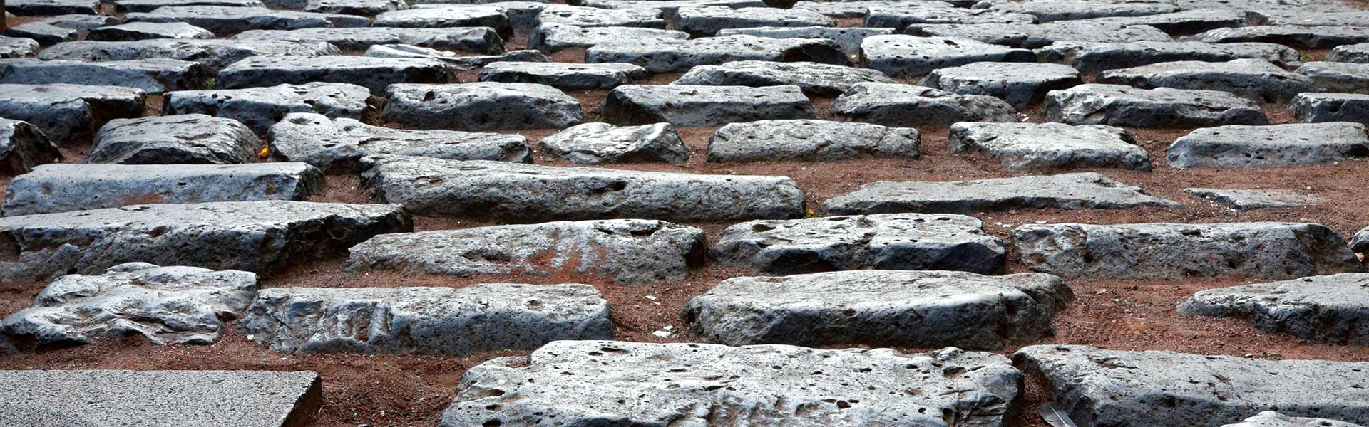
The Roman roads in Magna Germania were not like the well-developed and paved streets, as they have partially been constructed in the rest of empire (e. g. the famous VIA APPIA). The construction of such roads probably was not possible for the Romans in the relatively short period of provincialism in Germania Magna from 12 BC to 9 AD. The roads built in Magna Germania were more like grubbed and leveled paths (Wikipedia: Via Terrena), which enabled at least in the summer months a fast movinh forward for the Roman soldiers and civilians (dealers). Archeologists of the Ruhr University Bochum found at the documentation of a Roman road in Dorsten-Holsterhausen a width of 40 m, with 2 lateral drainage ditches (LWL Presse Info: Römische Marschlager).
2.3 Roman roads from the Rhine to the Hellweg Boerde
The first Roman garrisons on the Rhine north of the Central German Uplands were in Neuss (Novaesium) and Xanten (Vetera). This indicates that these two places had a special strategic significance, thus that they supervised important traffic routes to the east into the interior of Germania, which also the Romans could use for the advance into the interior of Germania. In the case of Xanten this was the Lippe as water transport route, in the case of Neuss this was the ancient highway Neuss-Herdecke, together with the extension of this Altstrasse to Wickede as connection to the Haarweg.
The excavations of Dorsten show that also along the Lippe a road was built by the Romans. Also the ancient highway Neuss-Herdecke was expanded in accordance with the Roman requirements, even today this road is called in some parts ‘Römerweg‘ (‘Roman way’) or ‘Römerstraße‘ (‘Roman street’).
As a further east-west connection the Hellweg was built or expanded by the Romans, probably as signal way, s. chap. 1.4.
Mit dem Laden der Karte akzeptieren Sie die Datenschutzerklärung von Google.
Mehr erfahren
Fig. 2.3-1: Course of ancient highway Neuss-Herdecke and connection to Haarweg at Wickede
The ancient highway Neuss-Herdecke guaranteed in its function as a ridgeway indeed solid ground, however also had the disadvantage of many to be surmounted gradients, which made the transport of heavy loads difficult, s. profile of the route Gevelsberg to Herdecke on the ridge road. Thus a route through the would Wuppertal Depression have been advantageous for the transportation of loads, s. profile of the route Gevelsberg to Herdecke through the Ennepe valley. The depression consists of highly folded, eroded by high rainfall and karstified corallian limestone, which is on an average altitude of 200 m on a long range flat. To the north and south steep slopes rise to high mountain ridges and plateaus. Island-like emergences like the Linderhauser Ruecken subdivide the Wuppertal Depression. (Wikipedia: Wuppertaler Senke)
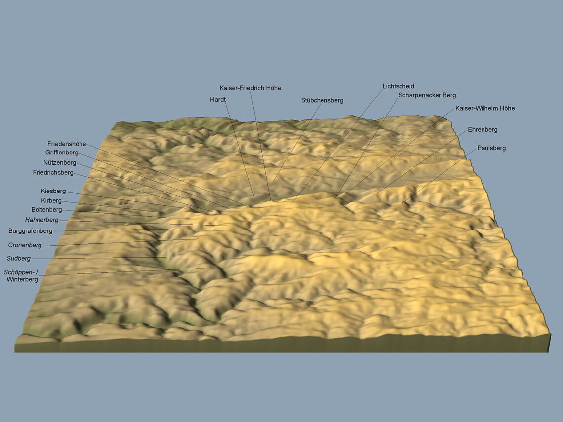
Abb. 2.3-2: Relief of the Wuppertal Depression – Morty, Wuppertaler Berge, CC BY-SA 3.0
Thus the route would have led through the flat river valleys of the Wupper, Ennepe and Ruhr, only intermittent by a short distance of a ridgeway from Heckinghausen via the Linderhauser Ruecken to Gevelsberg. Since river valleys in ancient times were swampy, this route would have required to build long causeways (lat. pontes longi), with the disadvantage of costly maintenance. However the ancient sources report that Lucius Domitius in his time as commander in Germania after 3 BC had built long causeways in Germania (Wikipedia: Lucius Domitius).
For the connecting roads between the Rhine and Hellweg Boerde (along the Lippe, Westphalian Hellweg, ancient highway Neuss-Herdecke), the following picture emerges:
Mit dem Laden der Karte akzeptieren Sie die Datenschutzerklärung von Google.
Mehr erfahren
Fig. 2.3-3: Roman roads between Rhine und Hellwegboerde
2.4 The Roman road network around the Hellweg Boerde
One main route from west to east is based upon the Westpkalian Hellweg (Wikipedia: Hellweg). The Hellweg is a 5000 year old trade route, leading from the Rhine through the Ruhr district and the Westphalian bay toward the Weser Uplands, and from there on eastward, which means towards those parts of the province in the Magdeburg Boerde.
Another route from west to east is based upon the the Haarweg (Wikipedia: Haar).
With the Herßweg (new also Hirschweg) there was also a route coming from Hesse going via Warburg, the Sintfeld, Buren and Lippstadt in direction northwest towards the Netherlands / North Sea.
The for the Romans in the middle Westphalian Bay available protohistoric highway system illustrates according to H. C. Poeschel in Spieker 17 (Protohistoric highways in the middle Westphalian bay) as follows:
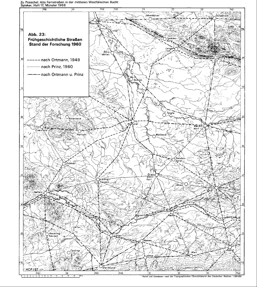
Fig. 2.4-1: Protohistoric highway system in the middle Westphalian bay (H. C. Poeschel in Spieker 17)
The ‘Frankfurter Weg’, partially also called ‘Bremer Weg’, is a former Via Regia, which led from Frankfurt am Main via Paderborn and Lemgo to Minden, and then from there on the right bank of the Weser to Bremen. Thus it connected the areas of the Rhine and the Main with those of the Weser and the North Sea. The Frankfurter Weg was already known in the antiquity as a Tin and Amber Road. (Wikipedia: Frankfurter Weg)
Thus the protohistoric highway system available in the eastern Westphalian Bay illustrates according to Fr. Copei in Mannus (1938) p. 64-91 (Protohistoric highways in the Senne region), online at [Logistik des Varus], as follows:
This highway system was extended by the Romans according to their military and economic requirements.
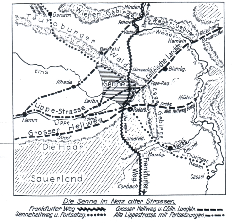
Fig. 2.4-2: Protohistoric highway system in the Senne region
2.5 The Roman road from the Hellweg Boerde to the Magdeburg Boerde
Between the Hellweg Boerde and the Magdeburg Boerde already in Roman times there was a trade route or ancient highway, from which the present federal highway 1 has its origin (Wikipedia: Bundesstraße 1). This route was used by the Romans for the transport of goods, such as salt or grain.
Sometimes the Romans had to adapt or even to expand the existing traffic route. This shows the transition between the linear construsted section in the Westphalian Bay and the Weser Uplands at the Egge. Although the current B1 between Bad Lippspringe and Horn leads through the valley of the Strothe, the linear extension ends more to the north where the L937 transits from the ‘Fürstenallee’ into the ‘Paderborner Straße’:
Mit dem Laden der Karte akzeptieren Sie die Datenschutzerklärung von Google.
Mehr erfahren
Fig. 2.5-2: Different routes for the transit of the Westphalian Hellweg (blue) over the Eggegebirge between Bad Lippspringe and Horn through the valley of Strothe (red), through the valley of the Berlebecke (yellow) and through the Defile Grosse Egge (green)
The shortest and affiliated with the fewest pitches path leads along the course of the current B1 through the valley of the Strothe. This valley is narrow and bordered by steep slopes, the at that time marshy ground and especially the flood risk given in spring therefore could not be bypassed by paths on slopes or by causeways through the valley. So especially in the spring with the beginning of the military activities the way through the Strothe valley was so often impassable for a Roman military unit with entrained cars.
A better because open year-round route arose further north through the valley of the Berlebecke. Here too a stretch of water flowed through the valley, however the slopes of Berlebecke valley are not as steep as those of Strothe valley, allowing paths on a slope above the stream bed. For this reason, the Hellweg was constructed linearly to the beginning of the Berlebecke valley. The disadvantage of the route through this valley is that it is relatively long.
A substantial shortening of the route was acheived by the construction of the Defile Große Egge. With this defile a pass previously impassable for cars over the Egge was made passable:
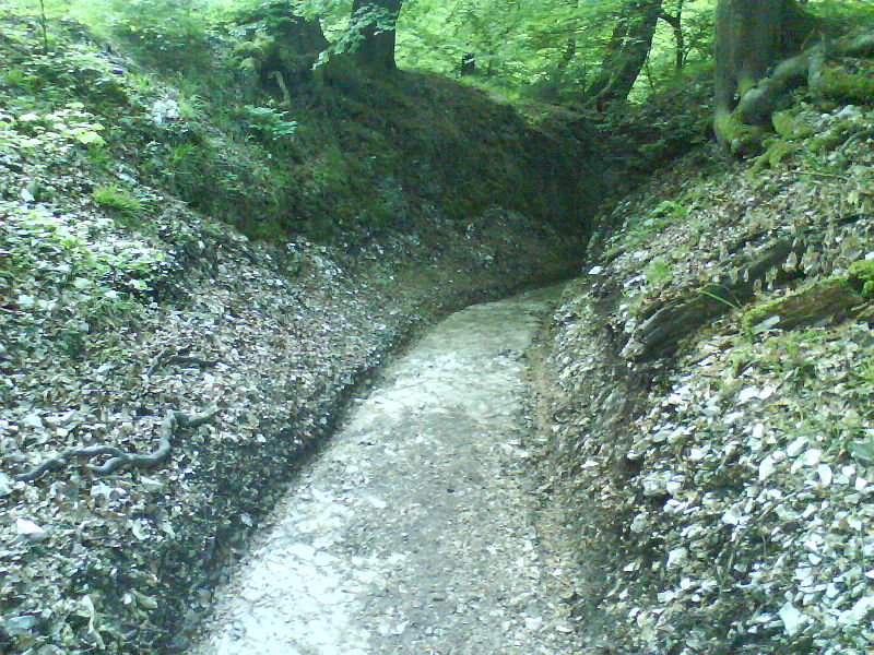
Abb. 2.5-3: Defile Grosse Egge – Skraemer, HohlwegExternsteine, CC BY-SA 3.0
2.6 The Roman road from the Hellweg Boerde to the Thuringian basin
For the Roman road between the Westphalian Bay and the Thuringian Basin with the Roman camp Hedemuenden there is a fixed point. An important prehistoric highway that leads from Westphalia approximately in the direction of Hedemuenden is the ‘Herssweg ‘, also called ‘Hirschweg’. In a document from 1451 that old route is called the “via regia dicta hersewech". Besides various spellings of the name ‘Herssweg’, which presumably refers to old Low German ‘horse’, also ‘Heerweg’ and in newer cards ‘Hirschweg’ are common. Coming from Hesse, this Via Regia took course via Warburg, Blankenrode, the Sintfeld, Buren, and further via Lippstadt to the Netherlands. (From: Rundblick Bad Wuennenberg, 21. April 2000)
On a route corresponding to the Herssweg the Romans have moved with high probability between Westphalia and Thuringia, possibly the Werra river ford at Hedemuenden was also part of this route.
Mit dem Laden der Karte akzeptieren Sie die Datenschutzerklärung von Google.
Mehr erfahren
Fig. 2.6-1: Herssweg (purple), Haarweg (beige) and Lippe/Alme (blue) in der eastern Wetphalian Bay
The Herssweg crosses the Alme at Bueren. Since the transport of goods by water was more efficient than by road, it is to verify, whether the Romans have made the by nature for the most part not navigable Alme river navigable. The problem of the Alme is, that it temporary falls dry in the summer months due to the karstic underground in the section between Bueren and Ahden-Borchen (Altenau-confluence), respectively the water drains in ponors.
However, Roman engineers were well versed in making rivers in Germania navigable (Wikipedia about Holsterhausen: In the period from 1999 to 2001 extensive archaeological excavations were made by W. Ebel Zepezauer, in which up to seven further camps of different sizes were discovered. They served as pioneer camps for various detachments including making the river Lippe navigable. By straightening the waterway between Vetera (Xanten) and Holsterhausen has been reduced by approximately 25%.)
With falling dry rivers in karst landscapes, the Romans had also learned to deal in their Mediterranean homeland, including the closing of ponors. At least at the time of floodings in the spring, thus just at the beginning of the military activities of the year and the resulting increased demand for transport, the Alme would have been a relatively efficient transport route. Since the project of navigability was militarily reasonable, technically feasible, and as well also affordable (with the legionaries stationed in the Roman camp Anreppen which had to be paid anyway, there were enough skilled labor available), the project was implemented with a high probability.
Due to ore mining in the area of Brilon and in the northern Sauerland generally (Wikipedia: Mining in the Sauerland, LWL: Roman-Germanic lead economy in Westphalia), the river Alme as a transportation route was more important for the Romans than the current upper reaches of the Lippe. For this reason, the question arises whether the Alme was the upper reaches of the Lippe for the Romans, and the today’s Lippe between Bad Lippspringe and Paderborn just an inflow. A Latin name of Alme is also not known.
Since the Roman camp Hedemuenden existed only to until ca. 7 BC it can be assumed, that the Roman eastern frontier in Germania has been brought forward at this time from the Werra, as the next frontier river the Saale lend itself to. Since the Roman camp Hedemuenden was in the range of the ancient highway Heidenstrasse it can be be assumed, that the camp supervised a ford of the Heidenstrasse through the Werra, and that the successor-camp also supervised a ford, in this case through the Saale. The Heidenstrasse crossed the Saale in the area of Merseburg, thus the successor-camp of Hedemuenden was probably built at Merseburg. The chronicler Thietmar from Merseburg in fact reports, that King Henry I in 922 attached an ancient installation of the Romans with a wall: “Antiquum opus Romanorum muro rex praedictus in Mersburg decoravit lapideo." (Beiträge zur thüringisch-sächsischen Geschichte).
Since the Roman camp Merseburg was the direct successor of the Roman camp Hedemünden, it had the same design as the Roman camp Hedemünden, thus it looked like a Bronze Age ring wall. This is due to the fact that it was built by the same Celtic auxiliary troops, see chap. 1. Such a ring wall in Merseburg, resembling a wall from the Bronze Age, has meanwhile also been archaeologically documented: “The latest archaeological finds show that it was a Bronze Age wall that actually enclosed the entire Domberg. King Heinrich I had this wall with him reinforced by a stone wall. " from: Marcus Cottin, Merseburg – die “Marsburg" – eine “kaiserliche Gründung" Julius Caesars, in: 1000 Jahre Kaiserdom Merseburg, Petersberg 2015, P. 184
Mit dem Laden der Karte akzeptieren Sie die Datenschutzerklärung von Google.
Mehr erfahren
Fig. 2.6-3: Bringing forward of the Roman border from Hedemuenden (red) on the Werra (blue) to Merseburg (yellow) on the Saale (light blue) along the ancient highway Heidenstrasse (heathen street) (brown)